
De-overlap vector strokes to prevent overdrawing.
Source, examples and issues: github.com/piLeoni/deoverlap
Where strokes run on top of each other, deoverlap keeps one and cuts the others back, so no area gets drawn twice. One Rust engine, three front ends: a Python library (Shapely geometries), a vpype command for SVG plotter pipelines, and Node.js bindings over flat coordinate buffers.
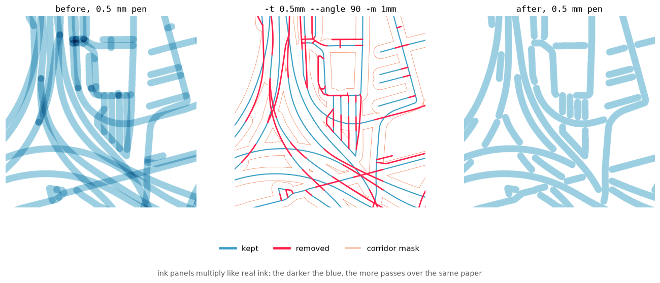
A street map drawn with a 0.5 mm pen: before (left), what was cut away (middle), after (right). Blue is kept, red is removed, orange is the corridor mask — the same colours in every figure below.
pip install deoverlapfrom shapely.geometry import LineString
from deoverlap import deoverlap
geoms = [
LineString([(0, 0), (2, 0)]),
LineString([(1, 0.05), (3, 0.05)]), # parallel, 0.05 away
]
result = deoverlap(geoms, tolerance=0.1)
print(len(result.kept), "surviving geometries") # 2: the second is cropped
print("wholly removed:", result.wholly_removed) # []tolerance is a distance in the same units as the geometries: strokes closer
than this to a kept stroke are cut. For a plotter, use the pen width.
pip install "deoverlap[vpype]"
vpype read map.svg deoverlap -t 0.1mm -l 1,2,3 write out.svg
Same options as the Python function (--self-overlap ↔ self_overlap=True);
only the tolerance has a default here, 0.1mm. Full flag list:
vpype plugin.
npm install deoverlapGeometries are flat coordinate arrays; the Node guide has JavaScript examples for every option and a GeoJSON converter.
Geometries are processed one at a time, in priority order. Each kept stroke
gets a corridor of radius tolerance around it, and every later stroke loses
the parts that fall inside a corridor. The options below decide which stroke
goes first (prefer), which nearby strokes count as overlapping (angle),
and what to do with the leftovers of a cut stroke (drop, min_length).
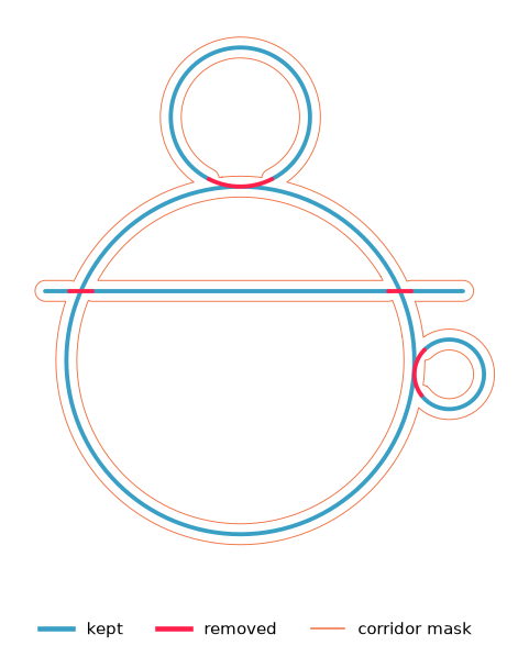
The processing order decides which of two overlapping strokes is kept whole:
prefer= |
Behaviour |
|---|---|
longest (default) |
The stroke that covers more ground wins |
first |
Input order |
shortest |
Short marks / detail win |

Original indices are preserved in result.kept_parts / removed_parts even
when processing order changes.
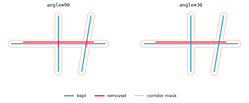
Two strokes overlap only where their directions differ by at most angle
degrees (default 30). Parallel runs and shallow merges are cropped; crossings
steeper than that are left alone. angle=90 counts every nearby stroke, so
crossings get cut too.
result = deoverlap(geoms, tolerance=0.1, angle=90) # cut crossings tooDirections are compared locally, edge by edge, so a curving ramp is cropped only where it actually runs alongside another road, whatever direction its two ends point in.
Where two strokes meet at an angle θ, they overlap for roughly pen / sin θ:
about 2 pen widths at 30° and 4 at 15°. The default of 30° catches parallel
runs and trims shallow merges; 45° or 60° trim steeper merges too.
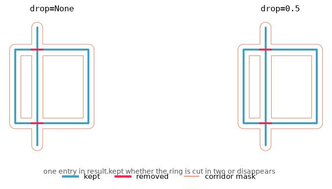
By default the overlap is cut away and the rest of the stroke is kept. With
drop=0.5, a stroke that would lose more than half its length is discarded
whole instead of leaving stubs.
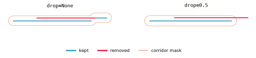
A dropped stroke has no entry in kept_parts and its index is listed in
wholly_removed. With keep_duplicates=True, removed_parts holds the
original geometry unchanged.
min_length= drops pieces shorter than that after cutting (points are never
removed by it).
A ring crossed by another stroke is cut into two arcs. They come back as
one MultiLineString under the ring's input index, not as two anonymous
pieces:
cutter = LineString([(1, -1), (1, 3)])
ring = LineString([(0, 0), (2, 0), (2, 2), (0, 2), (0, 0)])
result = deoverlap([cutter, ring], 0.15, prefer="first", angle=90)

result.kept_parts[1]  # MultiLineString with both arcs
One colour per object. On the left, both halves of the ring are one entry of
result.kept; on the right, flatten_geometries(result.kept) splits them
into separate single parts, when that is what you need:
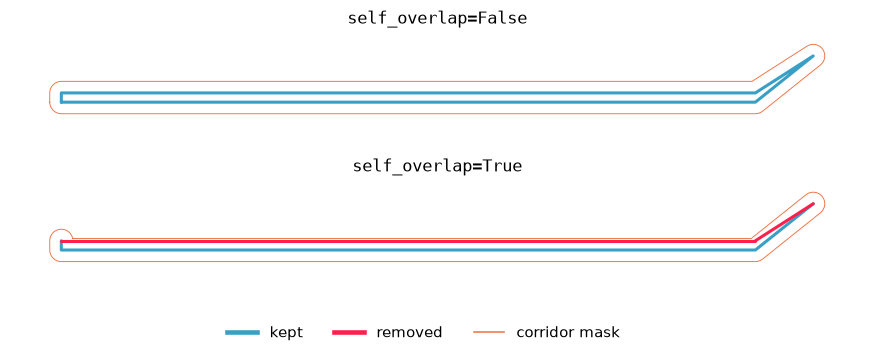
A thin road outline is often one LineString (left kerb → end cap → right
kerb). Normally deoverlap never compares a geometry to itself, so the two sides
stay as a heavy double stroke. With self_overlap=True every edge is its own
corridor, so opposite sides can suppress each other. Neighbouring edges never
cut each other, so joints are not nibbled, unless the path folds back on itself
like a hairpin.
To process batches separately (for example, main roads first, then side
streets), pass the previous result as mask:
r1 = deoverlap(batch1, 0.1)
r2 = deoverlap(batch2, 0.1, mask=r1)  # or mask=r1.mask
Stage 2 is clipped against everything stage 1 kept.
deoverlap(...) returns a DeoverlapResult:
| Field | Meaning |
|---|---|
kept |
Surviving geometries, one per input that kept something, in processing order |
removed |
Cut pieces, flattened (if keep_duplicates=True) |
kept_parts |
{input_index: geometry} |
removed_parts |
{input_index: geometry} (if keep_duplicates=True) |
wholly_removed |
Indices of inputs with nothing kept |
mask |
Corridor polygons, for a next stage |
The Python wheel is a compiled extension (no Rust toolchain at install time). The engine builds no polygons: the corridor of a straight edge is a capsule, and the part of another edge inside it is computed exactly. On the MacArthur Maze map below (1473 paths) a run takes about 30 ms.
pip install "deoverlap[vpype]" registers a deoverlap command. Each layer
is processed on its own; -l picks which ones.
| Flag | Default | Meaning |
|---|---|---|
-t, --tolerance |
0.1mm |
Corridor radius, usually the pen width |
--prefer |
longest |
longest | first | shortest |
--angle |
30 |
Max direction difference in degrees; 90 cuts crossings too |
--self-overlap |
off | Let parts of one path cut each other |
-m, --min-length |
0mm |
Drop pieces shorter than this after cutting |
--drop |
off | Discard a stroke when more than this fraction would be cut |
-k, --keep-duplicates |
off | Keep removed pieces in a separate layer |
-p, --progress-bar |
off | Display a progress bar |
-l, --layer |
all |
Target layer(s) |
-t, -l, -k and -p follow the usual vpype conventions; -m matches
vpype filter.
Chain the command to give each layer its own settings:
vpype read map.svg \
  deoverlap -t 0.1mm -l 3,4 \
  deoverlap -t 0.15mm --self-overlap -l 5 \
write opt.svgexamples/parallel_strokes.svg is a tiny card with two near-parallel pairs
(0.05 mm apart), one deliberate cross, and a dual-kerb rectangle drawn as a
single polyline. Run the commands and open the outputs side by side.
# Inspect path count / drawn length
vpype read examples/parallel_strokes.svg stat

# Crop near-parallel duplicates; leave the perpendicular cross alone
vpype read examples/parallel_strokes.svg \
  deoverlap -t 0.1mm -l 1 \
  write examples/out_parallel.svg

# Same, but also let the dual-kerb ring collapse against itself
vpype read examples/parallel_strokes.svg \
  deoverlap -t 0.12mm --self-overlap -l 1 \
  write examples/out_self_overlap.svg

vpype read examples/out_parallel.svg stat
vpype read examples/out_self_overlap.svg stat
What to look for (in the SVG or in stat’s drawn length):
- Before — each parallel pair is a double stroke; the ring reads as a heavy double outline.
out_parallel.svg— each pair reduced to one survivor; the cross still there; the ring still double (one geometry cannot overlap itself).out_self_overlap.svg— the ring’s opposite sides suppress each other, so the dual kerb thins toward a single outline.
examples/macarthur_maze.svg is a 3 km square of Oakland's MacArthur Maze
interchange from OpenStreetMap, scaled onto a 100 mm card (1 mm ≈ 33 m). At
that scale dual carriageways, stacked ramps and frontage roads sit a fraction
of a millimetre apart, so a 0.5 mm pen draws the same paper two or three
times. Set the tolerance to the pen width: anything closer than that would
overlap on paper.
vpype read examples/macarthur_maze.svg stat
vpype read examples/macarthur_maze.svg \
  deoverlap -t 0.5mm --angle 90 -m 1mm \
  write examples/out_maze.svg
vpype read examples/out_maze.svg stat
The whole card after this run; the dashed box is the zoom shown at the top of this page:
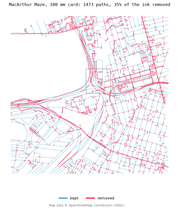
--angle 90 is the maximum: every nearby stroke counts, whatever its
direction. Side streets stop where the main road's ink begins, and at crossings
the shorter path is split around the longer one. The gap is exactly the other
road's ink width, so on paper the crossing still looks whole, just without the
dark spot of doubled ink.
Cutting leaves fragments; almost every piece under 1 mm on this card is one.
-m 1mm (two pen widths) drops them. The path count goes from 1473 to 860 and
the drawn length drops by 35%.
With the default --angle 30 crossings are left alone: parallel runs are
still merged, but both roads are drawn through every junction, and the card
loses about 23% instead of 35%. The same zoom, crossings kept and cut:
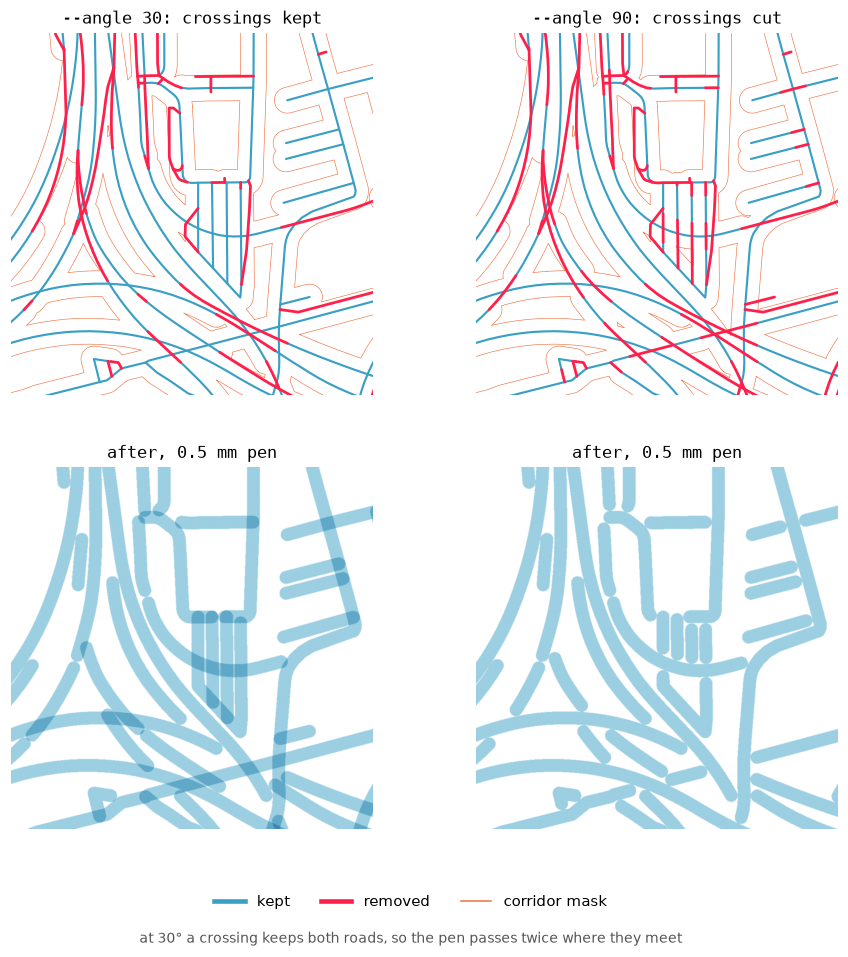
Keep crossings when every stroke must stay continuous (e.g. for later editing); cut them when only the ink on paper matters.
To try another place (needs pip install osmnx):
python examples/fetch_osm_example.py --lat 51.5074 --lon -0.1278 --radius 1500 \
  --out examples/my_place.svg
All README figures are rendered from the committed files by
python examples/make_figures.py (needs matplotlib).
Map data © OpenStreetMap contributors, available under the ODbL.
deoverlap(
    geometries,
    tolerance,
    *,
    prefer="longest",      # longest | first | shortest
    angle=30.0,            # degrees, 0–90; 90 cuts crossings too
    self_overlap=False,
    min_length=0.0,
    drop=None,             # fraction 0–1; None always crops
    keep_duplicates=False,
    progress_bar=False,
    mask=None,
) -> DeoverlapResult